
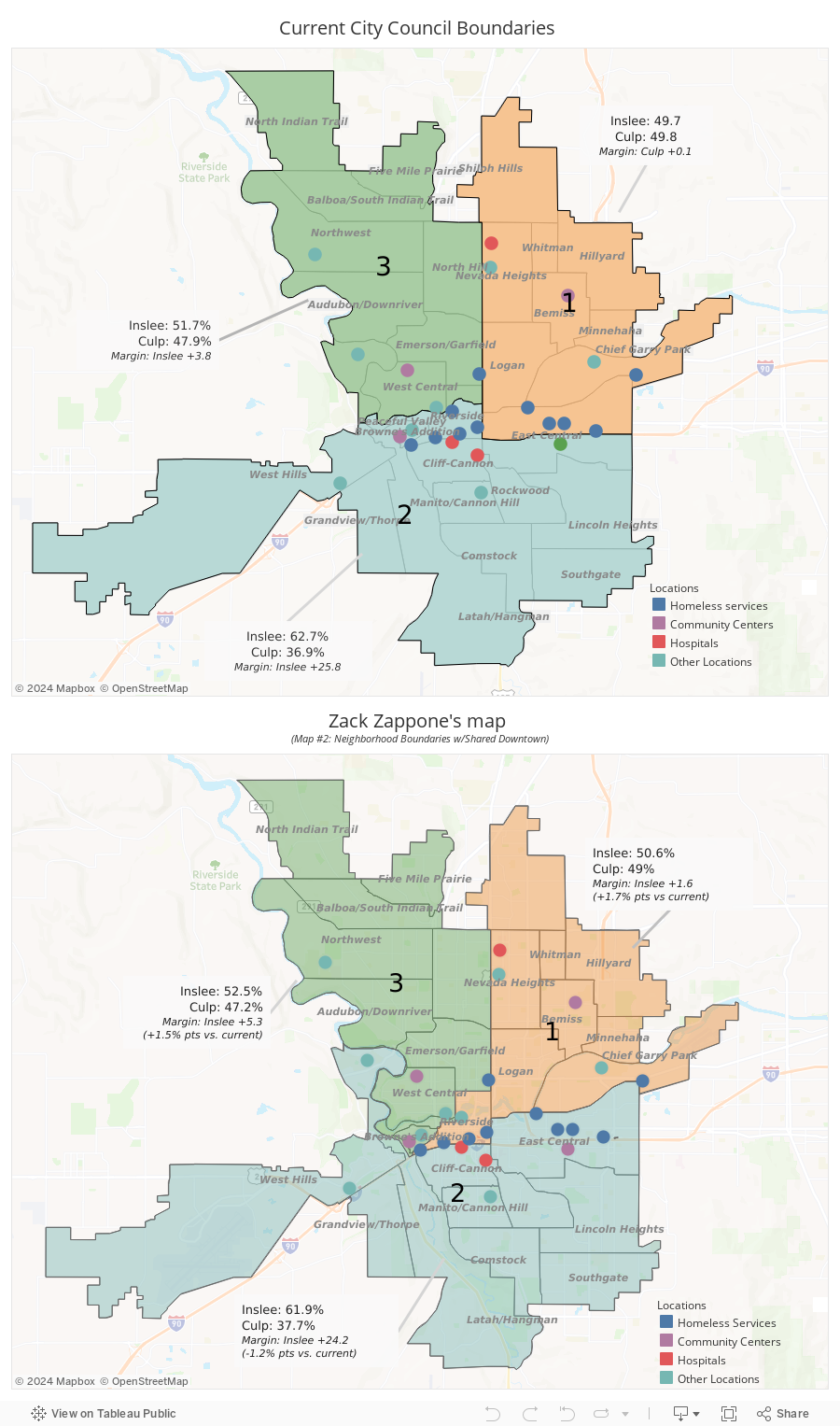
Zack Zappone's design; Daniel Walters Tableau data visualization
Stick a bit of Browne's Addition in District 3, and reelection for progressive candidates get a bit easier.
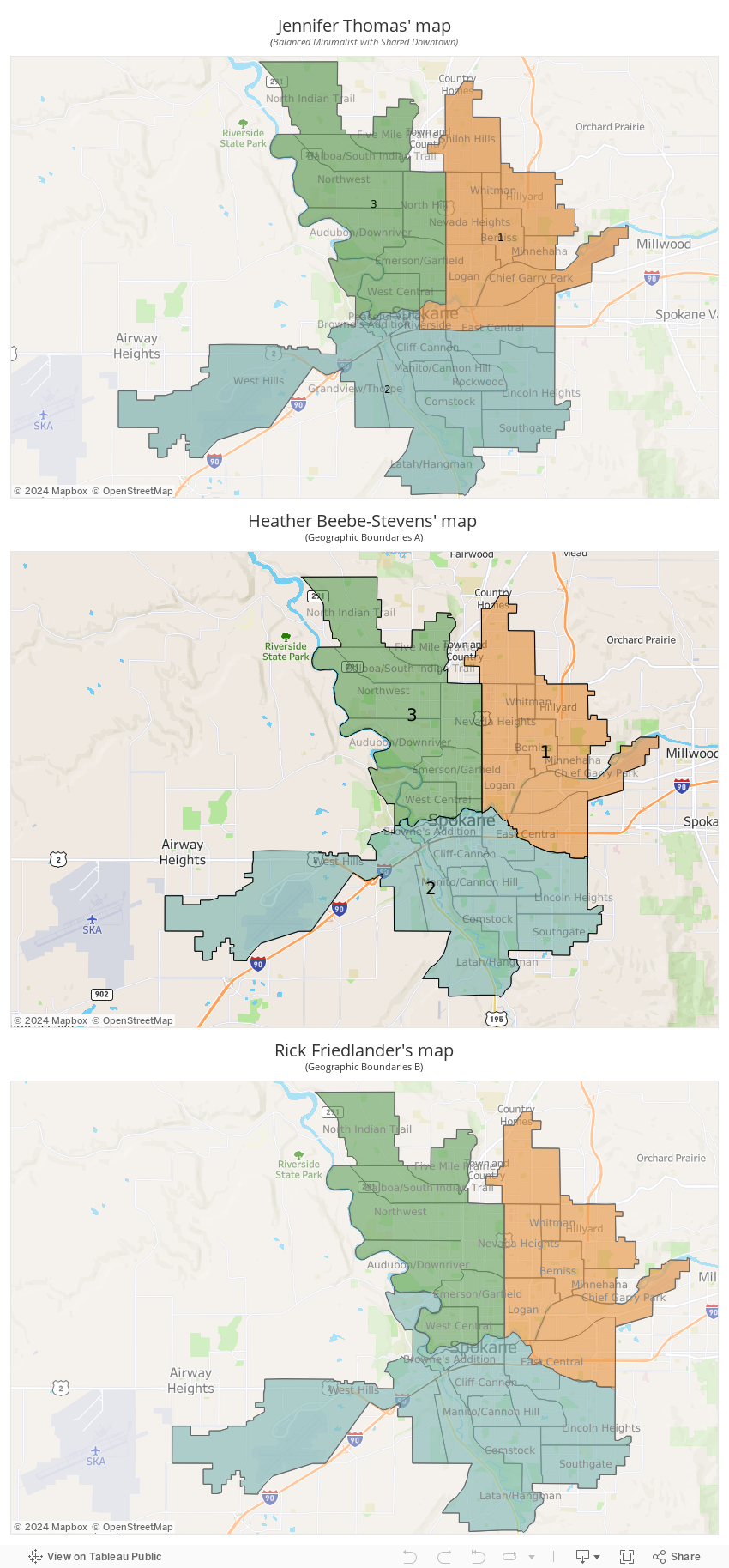
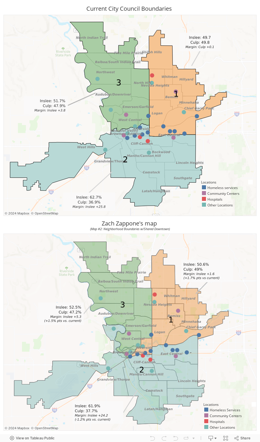
But if Map #2 from the City of Spokane Redistricting Board is approved, his reelection fight would get a bit easier. That map, "Neighborhood Council Boundaries with Shared Downtown," pulls the solidly blue Browne's Addition neighborhood into Zappone's district, while trading away the more politically mixed northern piece of the West Hills neighborhood into District 2.
And in a small but significant way, that's a better map for Democrats.
During the 2020 election, that map would have been enough to boost Governor Jay Inslee's margin of victory in District 3 by 1.5 percentage points and Joe Biden by 1.4 percentage points. It would have bumped U.S. Sen. Maria Cantwell in 2018 and Hillary Clinton in 2016 both up by 1.6 points. And while council races are technically non-partisan, considering Zappone had been a Democratic state representative candidate himself in 2020, it would likely help Zappone during his re-election as well.
And Zappone, it turns out, was the one who designed the map:
While the Redistricting Board approved Zappone's map as one of the four they wanted to get community feedback on, it rankled Jennifer Thomas, the Redistricting Board's representative for northeast Spokane's District 1.
"I am not loving that there is a map by a City Council member that has bias in it," says Thomas, who also serves as a spokeswoman for the Spokane Association of Home Builders. "It makes [Zappone's] race easier."
By taking the position as a voting volunteer on the Redistricting Board, she was barred from running for election or even donating to a council race for two years. But Zappone, an advisory member of the board, has no such restrictions.
Zappone swears up and down that he had no political motivation in his proposed map. Any political benefit, he argues, was coincidental.
"It's the only viable map that meets all their goals," Zappone says.
He says he made a number of maps, with two particular community goals in mind: Keeping neighborhood councils intact and splitting Downtown Spokane between the three districts.
On top of that, he was restricted by the actual legal guidelines of the process: Keep it compact, without sprawling tendrils. Keep populations roughly equal. Follow natural geographical boundaries where you can. And no radical changes.
While Zappone knows how easy it is to use the board's redistricting tool, Dave's Redistricting App, to check on the political ramifications of a boundary revision, he says he "did not, because that was not what we were tasked to do."
Rick Friedlander, a retired medical sales representative who represents District 3 on the board, says he doesn't see an issue with Zappone's proposed design.
"I don’t see any agenda in Mr. Zappone’s art in doing that," Friedlander says. "I see creativity and openness — creativity in coming up with a solution to a multi-variant problem."
He says Zappone did a good job.
"We all took several stabs at trying to have downtown be part of each of the districts," says Friedlander. "Mr. Zappone’s was the most successful of the six or seven we looked at."
Friedlander downplays the original authorship of the various drafts of the maps. So does Zappone.
"These are no longer individual maps," Zappone argues. "It's not my map. These are the commission's maps because all three commissioners voted to approve it."
Zappone points out that his map was almost identical to a map floated by Heather Beebe-Stevens, the Redistricting Board member representing South Hill's District 2.
Beebe-Stevens stresses the importance of keeping neighborhood council districts together. In recent months, Spokane City Council members have fought over, for example, which set of council members actually represent the East Central neighborhood. The section of the neighborhood north of the freeway where Camp Hope is located is represented by Michael Cathcart and Jonathan Bingle of District 1, while the section south of the freeway is represented by Lori Kinnear and Betsy Wilkerson.
"It’s important to me to take the history of what’s happening in different parts of Spokane. East Central was split by I-90," says Beebe-Stevens. "That neighborhood had no voice when it got divided.”
None of the three other maps selected by the committee, however, made District 3 more Democratic.
But even setting aside the conflict of interest question, Thomas says Zappone's map is flawed.
"It's not as compact as everybody else's," Thomas says. "It doesn't follow natural boundaries. And it splits six precincts."
Zappone's map has even more of an impact on the swingiest district in the city — Northeast Spokane's City Council District 1. Culp actually narrowly won that district in 2020. But under Zappone's map, Culp would have lost by a percent and a half. The other maps, however, including Thomas's, also make it a bit harder for conservative council members to get reelected there.
Indeed, almost any map that tries to split downtown between the three districts will likely make things harder for Republican candidates. As with most cities, the city core of Spokane (currently in District 2) is pretty deep blue. Add more of the core to District 1 and District 3 and those will lean more Democratic.
The city council members, including Zappone, will ultimately be the ones to approve or disapprove of the council map that could impact their political future.
"It's not a map that determines your future," Zappone argues. "It's who you are and the campaign you run and how you govern."
You can weigh in on the survey of the potential redistricting maps at this link.
Here are the three other maps as submitted. (Some of the maps have since been tweaked slightly by the county auditor to clean up some rough lines and try to align precincts.)