On Sept. 9, Clark records that "our guide informes that we should leave the river at this place and the weather appearing settled and fair I determined to halt the next day rest our horses and take some scelestial Observations. we call this Creek Travellers rest." They had reached the present-day junction of Highways 12 and 93, south of Missoula, Mont., and the approach to Khusahna Ishkit, or -- as it has subsequently come to be known in history -- the Lolo Trail. This passage had been used by the Nez Perce since the 1730s.
During the day of rest, while Lewis and Clark calculated longitude and latitude, the camp crew sewed moccasins and the hunters took to the field. In the evening, one of the hunters, John Colter, returned to camp with three Indians. Clark thought them Flathead Indians, but their knowledge of the trail across the mountains, and the statement by one of the men that he lived on the "plains below the mountains on the columbia river," encourages most readers of the journals to believe them to be Nez Perce tribesmen. The Indians said they were seeking the recovery of 23 horses stolen by raiders. Two of the Indians departed the camp of the explorers after sunset, but the third volunteered to remain with the Corps as a trail guide.
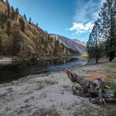
The passage to Lolo Pass began in the late afternoon of Sept. 11 and accomplished a meager seven miles. The Nez Perce guide "thought proper to leave us" that evening, according to Clark. The Corps made an earlier start on the following morning, but rough terrain extended the day into night as "Some of our Party did not git up [to camp] until 10 oClock P.M." On the third day out from Traveler's Rest, Lewis and some men delayed to recover stray horses, so Clark's forward unit was the first to reach the Lolo Hot Springs in Missoula County, Mont. Clark "found this water nearly boiling hot" and "I put my finger in the water, [and] at first I could not bare it in a Second." That evening camp was made in an extensive meadow on the west side of Lolo Pass, bringing the Corps once again back to modern Idaho.
On Sept. 14, the Corps marched "9 miles over a high mountain steep & amp; almost inaxcessible [with] much falling timber which fatigues our men & amp; horses exceedingly." It need not have been so strenuous, as Old Toby missed a junction and followed the wrong trail off Lolo Pass. Instead of following the main trail going to the ridge, he led them down a footpath to a creek at the headwaters of the Lochsa River.
That night, the expedition camped at the present site of the USFS Powell Ranger Station. Sgt. Patrick Gass used a biblical reference to lament that "none of the hunters killed any thing except 2 or 3 pheasants; on which, without a miracle it was impossible to feed 30 hungry men and upwards, besides some Indians." Meantime, Lewis passed out some portable soup to the men, an unappealing concoction of flour, cornmeal, sugar, coffee, dried apples, and lard of which he had purchased 193 pounds for $289.50 in Philadelphia just for emergencies such as this. Gass asserts that "Some of the men did not relish this soup, and agreed to kill a colt; which they immediately did, and set about roasting it; and which appeared to me to be good eating." Clark named the adjacent watercourse Killed Colt Creek on his map.
After dinner, Sgt. John Ordway took refuge in his tent from the thunder, hail and rain. Even so, he could still see fearsome "high Mountains covered with Snow and timber." Soon Lewis and Clark would come to understand that they had strayed from the traditional trail and that it would be necessary for them to climb from the river to the ridge of those mountains just to regain it.
Next Week: Back on the Lolo Trail, the Corps discovers a Nez Perce village.
Robert Carriker has directed eight National Endowment for the Humanities seminars on the Lewis and Clark expedition and is author of Ocean in View! O! the Joy. When he's not out retracing the steps of the Corps of Discovery, he teaches history at Gonzaga University.