
Get out of the car, hop over a few thin streams and a rock amphitheater appears, its tall walls winding around, almost forming a perfect circle in the ground just south of Cheney.
Pillars of basalt cluster together forming high cliffs around the area, known as Williams Lake Cataract, but none of it will last. The cliff’s edge is precarious, and a sloping hill of broken, shattered pillars piles up at its base. A wetland sits in the valley below.
At the edge of the stone arena, John Soennichsen scans the horizon like a man out of time.
It’s not that he’s in a rush. He just doesn’t see this landscape as how it is now, barely after 9 on a Thursday morning that left an unseasonable covering of snow on the ground, with a cow peacefully lowing in the distance.
Instead, Soennichsen (“sun-icksun”) sees something that happened thousands of years ago. A torrent of muddy water is rushing around him, its surface high above. Something akin to a tornado — one made of water — has planted itself in front of him, tearing at the ground, gouging deep into the Earth, making the amphitheater deeper and wider.
“We’d be at the bottom,” he says. “The surface would have been 200 feet above us. From the air, this would have maybe looked like a ripple.”
And this is just one spot, just a few acres, in an area stretching from Montana to the Pacific Coast that suffered a similar cataclysmic fate. Many areas saw much greater destruction.
Beginning at about the same time humans are thought to have first moved into the area, great floods washed over the Inland Northwest every 50 to 100 years, perhaps a hundred of them in all. These ice age floods washed away every living thing, scraped away fertile topsoil, carved out the Columbia River Gorge and forever changed the landscape of the Pacific Northwest. The floodwaters ran from Missoula to the Pacific Ocean in a matter of weeks.
“Historically, no human has seen anything of this magnitude,” says Richard Orndorff, the head of the geology department at Eastern Washington University. “These are the largest floods to occur anywhere on Earth that we know of.”
For people like Orndorff and Soennichsen, it isn’t what the floods washed away that fascinates them. It’s what they left behind: giant gashes ripped in the Earth, waterfalls larger than Niagara but with no water, mysterious pits in the ground big enough to hold a mansion, craggy buttes of basalt pillars, layer after layer of sediment that look to have been left by a giant river where a giant river never ran. In all, it looks as if the earth has scabbed over recently torn flesh, mimicking something you’d see on Mars.
Soennichsen, who lives in Cheney, has become a local sage of sorts, looking into the region’s geologic past and translating what happened for the lay audience. As the author of the just-released Washington’s Channeled Scablands Guide, he’s once again told the tale of what happened here in the age of the mammoth. A few years ago, he wrote Bretz’s Flood, a well-received biography of J Harlan Bretz, the 20th-century geologist who first recognized the signs of a humongous flood in the braided networks of coulees and erratically strewn boulders of Eastern and Central Washington.
Soennichsen is not a geologist by training, but a writer. He’s just trying to tell a story.
“I worked at Eastern Washington University and befriended a lot of geologists,” he says. “Unlike some scientists, they love to explain their work.”
And as
Soennichsen has pointed out many times — in his books, during his
lectures — if you can read the landscape of Eastern Washington, you will
understand the story of the floods.
Pushing the bounds of human comprehension, some stories about geology begin with the words, “About a thousand million years ago…” Not this one. When this one began about 15,000 years ago, Earth’s most recent ice age was ending. Dinosaurs were long gone and the Earth’s continents, creatures and plants were as recognizable as they are to us today (though we’re missing a few giant animals that were around then: the 20-foot-tall giant sloth, the giant beaver, the mammoth and the sabre tooth tiger, to name a few). There’s a chance that people already called the Inland Northwest home.
Sheets of ice covered the planet’s cooler regions, and these were beginning to retreat as Earth warmed. As the Cordilleran ice sheet withdrew north, part of it blocked Montana’s Clark Fork River. The river’s waters continued to flow but had nowhere to go. Soon a lake 200 miles long and 2,000 feet deep sat behind this ice dam, covering present-day Missoula and its surroundings. Where Glacial Lake Missoula’s waves crashed can still be seen on the hills surrounding the college town as unearthly horizontal ripples.
As the world’s temperatures inched upwards, the ice dam melted and broke, sending an unimaginable amount of water rushing west, over Eastern and Central Washington, down the gorge, up Oregon’s Willamette Valley and into the Pacific Ocean. The lake, bigger than two of the nation’s Great Lakes combined, drained within a few days.
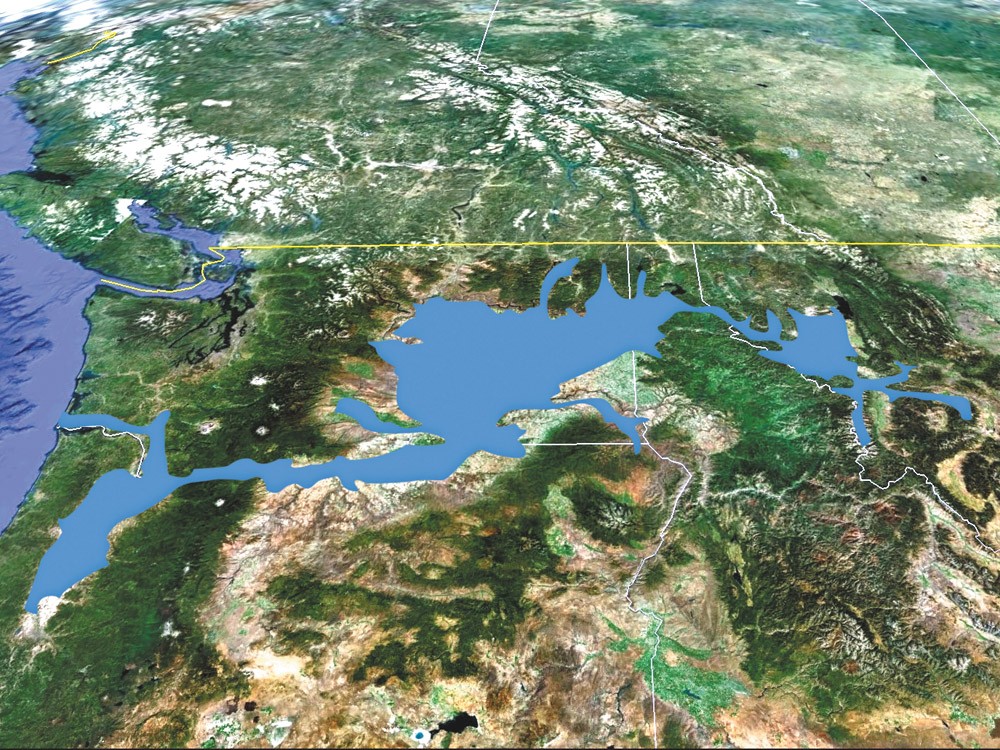
The path of the floods, from Montana to the Pacific Ocean
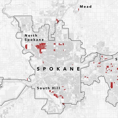
Anyone unfortunate enough to be standing in what is now Spokane the day the floods came would have seen a muddy torrent hundreds of feet tall rushing at 60 miles per hour into the Spokane Valley from Rathdrum Prairie.
Deep waters submerged the Valley, scouring the ground. The landmark knobs of black basalt that dot the region were unearthed by the floodwaters.
The cramped, icy mountain passageways the floodwaters took before entering the Spokane area didn’t provide much fodder for destruction. Heading toward Cheney, the floodwaters found their first real chance to spread out and tear up the yielding ground, where it is believed that, at the time, a landscape similar to the fertile rolling hills of the Palouse stretched across Eastern Washington.
With no big river to follow, the floods made their own way.
From high above, the path they took through Eastern and Central Washington would have looked like a complicated network of veins, braided channels that weave in and out of each other.
These are what University of Montana geologist David Alt calls “the classic, the granddaddy of all Scablands,” in his book Glacial Lake Missoula and its Humongous Floods. And it is this area that Soennichsen’s new guidebook seeks to explain. These are the channeled scablands, a broad expanse of interlaced gorges that cover much of this side of Washington. This carved-out topography defines the area that we all know today.
“If we look at the general landscape, Eastern and Central Washington were scoured by these floods,” says Orndorff, the EWU geologist. Name any feature on this side of the state and the floods were probably responsible.
Turnbull Wildlife Refuge, Grand Coulee, Soap Lake, the list goes on, Orndorff says.
Even our drinking water. “The Spokane Rathdrum Prairie Aquifer … is a sedimenthosted aquifer,” he says. “The sediment was deposited by those floods. … That’s Montana sediment. That’s why we have clean water.”
Even our recreation. “The floods created all of our lakes,” Orndorff says. “We have so many lakes — 80 lakes basically within an hour of Spokane. Those were all carved out by these floods … torn out by these fast-moving waters.”
It’s
also a region that many people might find alien. When the first
detailed images of Mars came back in the 1970s from NASA’s Viking
orbiters, scientist V.R. Baker noted the similarity between the
intertwined canyons on Mars and the scablands of Eastern Washington.
This led many to speculate that what happened here happened there, that
Eastern Washington’s topography isn’t simply Earthly, but also Martian.
It didn’t take sophisticated rocketry and planet hopping for J Harlan Bretz, a University of Chicago geologist, to recognize what forces that created the area that the first pioneers dubbed “the scablands.”
Before he pursued his eventual vocation, Bretz was a high school biology teacher in Seattle. It was then, in 1910, at age 27, that he first became enamored with Eastern Washington.
After looking at a map of the Potholes Cataract near Moses Lake, Bretz thought it looked like a large amount of water used to flow there, as if a massive waterfall once raged there.
“He no doubt asked people in the UW Geology Department about it,” says Vic Baker, a geosciences professor at the University of Arizona, in Bretz’s Flood. “And they probably said, ‘Yes, you’re right, that is interesting,’ but offered no solutions to this curious high school teacher. But it clearly stuck in his mind as an odd thing, and it no doubt served as a trigger for later thinking.”
A few years later, Bretz headed back to his native Midwest to pursue an advanced degree in geology at the University of Chicago. He wrote his dissertation on the glacial history of Puget Sound, but the scablands never left his thinking.
Every summer for seven years beginning in 1922, he came to Eastern Washington with some of his students to study the features in the landscape, which had until then been poorly explained, if explained at all. The thinking at the time was that glaciers carved out the scablands. Bretz never really believed it.
During those summers, Bretz and his crew went to Williams, Badger, Fish and Rock lakes. They explored coulees with names like Moses, Washtucna and Grand. They poked around Drumheller Channels and Palouse Falls. From Spokane to Wenatchee, and from the Tri-Cities to the Grand Coulee (before it was dammed), Bretz and his students studied the broken landscape, collecting evidence of these destructive floods.
Within a year, Bretz had formulated a theory of the only thing that could have caused the scablands: catastrophic flooding. Bretz believed that what he discovered had happened nowhere else on Earth.
When he published The Channeled Scablands of the Columbia Plateau in 1923, his colleagues reacted in a way familiar to those who come up with innovative ideas and theories. They rejected it.
At the time, the field of geology was going through a stage of professional growth, trying hard to earn the respect of its peers. Unlike physicists and chemists, who had already changed the course of the world with their advances in the previous century, geologists were still trying to show that what they studied had real-world effects.
“Geology was at an age when it was trying to prove itself,” says Soennichsen.
The field was deeply married to the theory of uniformitarianism, which assumed that laws governing the universe now have always governed the universe. In geology, this translated to a virtually unchanging Earth, where gradual processes altered the landscape over millions of years.
“And here comes this guy saying it all happened in two weeks,” Soennichsen says. Under the disapproving glare of his field’s elders, Bretz tooled around the nation’s outback with a hammer, resurrecting the idea of a great flood just years after the geological scientific establishment had abandoned the biblical explanation of a great flood — Noah’s — shaping the planet.
“Ideas without precedent are generally looked upon with disfavor and men are shocked if their conceptions of an orderly world are challenged,” Bretz wrote of the feud in 1928.
“Not only was he claiming something most people didn’t believe,” Soennichsen says more plainly, “he was also an asshole.”
Along with J.T. Pardee, the geologist who studied Glacial Lake Missoula, Bretz defended his flood theory for decades. It wasn’t until the 1970s that his ideas were vindicated and accepted as truth.
In 1979, decades after his work in the channeled scablands, Bretz finally won the Penrose Medal of the Geological Society of America, geology’s highest honor. His old age made him too frail to travel and accept the award, but he did tell his son, “All my enemies are dead, so I have no one to gloat over.”
He died two years later.
Leaving Eastern Washington’s scablands, the floodwaters continued on their southwesterly course, crashing through the Wallula Gap, a high-walled narrow passage that bottlenecked the water before it rushed down the Columbia River Gorge.
Before the floods, the walls of the gorge sloped gently downward to the river’s banks. But as the water raged through, as deep as 1,000 feet in some sections of the Gorge, it tore at these sides. Where creeks once gently flowed downhill to join the Columbia, now they tumbled off steep cliffs. Multnomah Falls is but one well-known example.
Still massive and moving fast, the floods completely inundated Oregon’s Willamette Valley.
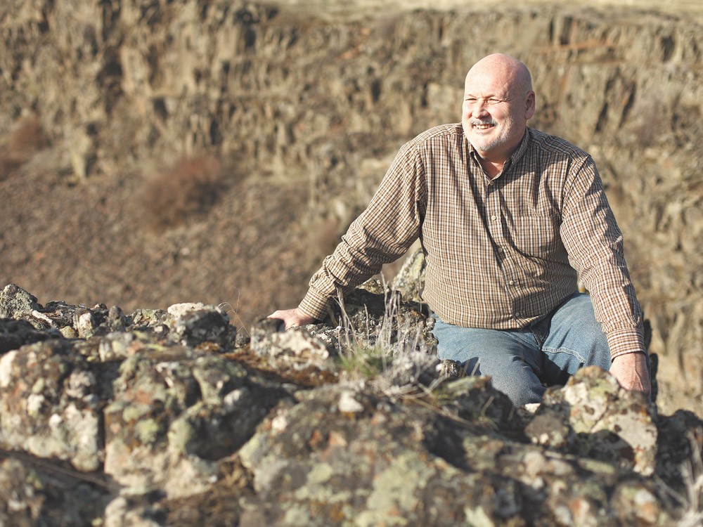
John Soennichsen just published his latest book, Washington's Channeled Scablands Guide. [Photo: Young Kwak]
From Portland to Eugene, slackwater collected as narrow points near Portland kept it from racing out as fast as it raced in. Due to the stillness of the water, much of the soil stripped from Eastern Washington’s plains was dropped here.
“It spreads the natural fertility of the Palouse Hills across the floor of the Willamette Valley,” writes Alt in Glacial Lake Missoula. “Think of all the barren bedrock in the … scablands as you pass the lush fields and the flourishing groves of fruit and nut trees in the Willamette Valley.”
What began high in the mountains of Montana finally came to an end just two or three weeks later when the powerful floods reached the Pacific Coast, where the Columbia River meets the ocean. The greatest flood in Earth’s history was over.
Fifty or so years later, it happened again. And again and again, perhaps up to 100 times for the next 5,000 years, as the ice dam would form and break again.
In all, the floods covered 16,000 square miles, more than four times the size of Yellowstone National Park.
“That’s the problem with the floods,” says Mark Buser, president of the Ice Age Floods Institute, which is based in Kettle Falls, Wash. “People have a hard time wrapping their minds around the enormity of the floods. Everything is on such a grand scale. One flood had 10 times the flow of all the world’s rivers combined.”
Getting people to appreciate the enormity of the flood is the institute’s main goal. Founded in 1995, it has been trying to get the word out about the floods, which were generally known by the scientific community, but not the public.
Since its inception, the institute has grown to 10 local chapters in four states, with 600 members. And it’s not a “geologists only” organization. Buser, its president, is a financial advisor in the Portland area, who focuses on tourism and economic development. Part of what intrigues him about what the institute has done, he says, is not just the science, but also the political science.
“I am fascinated by how citizens who appreciate the natural beauty of something can get a law through Congress,” he says.
In 2009, the institute was instrumental in convincing Congress to establish the Ice Age Floods National Geologic Trail. Just two months into his presidency, Barack Obama signed the trail into reality. When complete, the trail will be the first of its kind to commemorate the country’s natural history.
Unlike other national parks, the trail will be an independent unit of the National Park System. The federal agency will coordinate the planning and development of the trail, but the trail will be run by a collection of public and private organizations, most importantly the Ice Age Floods Institute.
This fall, the required “Foundation Statement” for the trail was released, detailing the major route of the trail and its many spurs. The main route stretches through four states from Missoula to Astoria, Ore., with countless waypoints in between. The statement also identifies the significant points along the trail that should have interpretive centers, hiking trails and more.
“Think of a string of pearls,” says Buser. “And the pearls are the most dramatic and beautiful sites, where it is most compelling to tell a story. Dry Falls, for example. … There are plans there for an extremely large interpretative center.
“The
features are so unique and abundant in the four states,” Buser says.
“They are nationally important, but they are also an international
phenomena. They’re known as the largest floods to ever occur on Earth.”
The clouds are dark and low, and the wind is strong at the south end of Rock Lake, the only public access point for the eight-milelong waterway.
As Soennichsen pulls into the gravel parking lot, hundreds of geese and ducks take to the air, disturbed by the human intrusion in this otherwise placid place.
“It just doesn’t feel right,” he says of the lake, making no motion to step from his car.
Rock Lake is the longest and the deepest of the scabland lakes, and it’s connected to Bonnie Lake in one long gash on the landscape just south of the Turnbull National Wildlife Refuge.
Basalt
cliffs 300 feet tall line Rock Lake’s edges, and they continue another
400 feet below the lake’s surface. Sharp-edged basalt columns wait just
below the surface in some parts of the lake, ready to tear into the hull
of any boat with an unsuspecting oarsman.
In his Pulitzer Prize-winning Annals of the Former World, John McPhee argues that “writing about geology is masochistic, mind-fracturing self-enslaved labor.” In his chapter on Rock Lake, which he calls the “eeriest of all scabland lakes,” Soennichsen proves him wrong.
“Just about every facet of Rock Lake is entwined with mystery,” he writes in the guidebook, which contains hikes around the scablands. “For centuries, Native Americans in the region have told stories of a sea serpent in the lake that would rip the bottoms out of … canoes and swallow the occupants. To this day, strange currents on the surface of the lake … only serve to sustain the legend.”
Sadly just last week, the dangerous lake took another victim when Christopher James Gormley’s kayak flipped on the choppy waters. The 18-year-old Gonzaga University freshman was wearing a life jacket, but was pronounced dead from hypothermia at the hospital.
Not all of Rock Lake’s stories are so tragic. There are rumors of an abandoned still in one of the caves near the lake, an artifact from the Prohibition era. And there’s the story of the derailed train cars that plummeted into the lake 100 years ago, never to be found. They were packed with brand-new Ford Model T cars.
Pulling away from the lake, heading to yet another strange, severe feature left behind by the floods, Soennichsen allows himself to speculate on the nature of the floods.
“They say there’s no reason why it wouldn’t happen again,” he says. “But we’ll probably be long gone by then.”
Excerpt from Washington's Channeled Scablands Guide

But just as the darkness of a bedroom with the lights turned off can never compare to the blackness of a cave with your lantern switched off, so is urban silence less pure, less absolute than the silence of natural settings. If we listen hard enough, even in the most noiseless of urban settings, there will always be the murmurs of man all about us—the humming and whirring and buzzing of noises we don’t even realize are constantly in our ears until we withdraw from that urban setting and experience a truly natural environment far from the influence of man.
Out in these places away from the domain of the human race, far from the machines, the music, from television and traffic and talk, you can slowly begin to understand what the true silence of the natural world is all about. This is the time when the sounds associated with civilization will slowly fade farther and farther away.
“Speech is civilization itself,” wrote Thomas Mann in 1924 in The Magic Mountain. “The word, even the most contradictory word, preserves contact — it is silence which isolates.”
But it is this same isolation from civilization, from contact with other humans, that allows for a contact to be made with nature and oneself. More to the point, it is that isolation and silence that allow a person to make contact with the dimension of time, the ruler of this and all other landscapes formed by geologic events occurring over numberless millennia.
In this natural world of silence, a person is best able to begin imagining the sounds that must have accompanied the natural forces that created this place. It is a silence that also allows you to imagine what people who may have lived here 15,000 years ago — and there is a very good possibility that people were here — might have heard and felt and seen through terrified eyes as a series of great, brown, thundering waves of slurry flowed across a formerly green and rolling landscape, first tearing at the soil, then snatching at the basalt columns beneath, peeling them off the cliff faces like some hungry grizzly peeling bark from a yellow pine.
At first, there would have been that same silence a visitor to this place experiences today. Then, even before the water arrived — perhaps as much as a half hour before — there would have been a thunderous noise, a strong wind, perhaps even the sense that there was the mist of some unseen moisture source in the air. Then the ground would have begun to shake and the hunters and gatherers experiencing all this might have received their first sensations that something quite ominous was about to occur.
The sounds of silence in this great geological landmark enhance the already powerful sensation it gives off as being a wilderness area worthy of both respect and caution.